![]()
T54 Trail
Alpine & technical trail run in front of spectacular scenery
54 km
Distance
4.020 hm
altitude meters uphill
4.020 hm
altitude meters downhill
August 09, 5:30 am
Start
90 %
Trail share


*Saaser Alp, walk to Klosters
Facts
| Start | 09. August 2025, 05:30, Klosters train station square |
| Registration & race bib | 08. August 2025, 15:00 – 20:30 |
| Finsih | Klosters train station square |
| Expected winner time | 12:00 (6.30 h) |
| Time limit | 18:30 (13.00 h) |
| Award ceremony | 16:00 |
| Character | tecnical, alpine trailrun |
| Difficulties | Downhill Alpenrösli – Schlappintobel; 3 Uphill to Jägglisch Horn, Eggberg and St. Antönier Joch; Rätschenhorn – Saaser Calanda – VP 5 |
| Trail share | 90 % |
| Food stops | 6 |
| Ideal for | Experienced Trailrunner |
| Highlights | View from Jägglisch Horn, Downhill to Gafia, Rätschenhorn, Ridge-Running towards Gafier Platten |
| ITRA-Points | 3 |
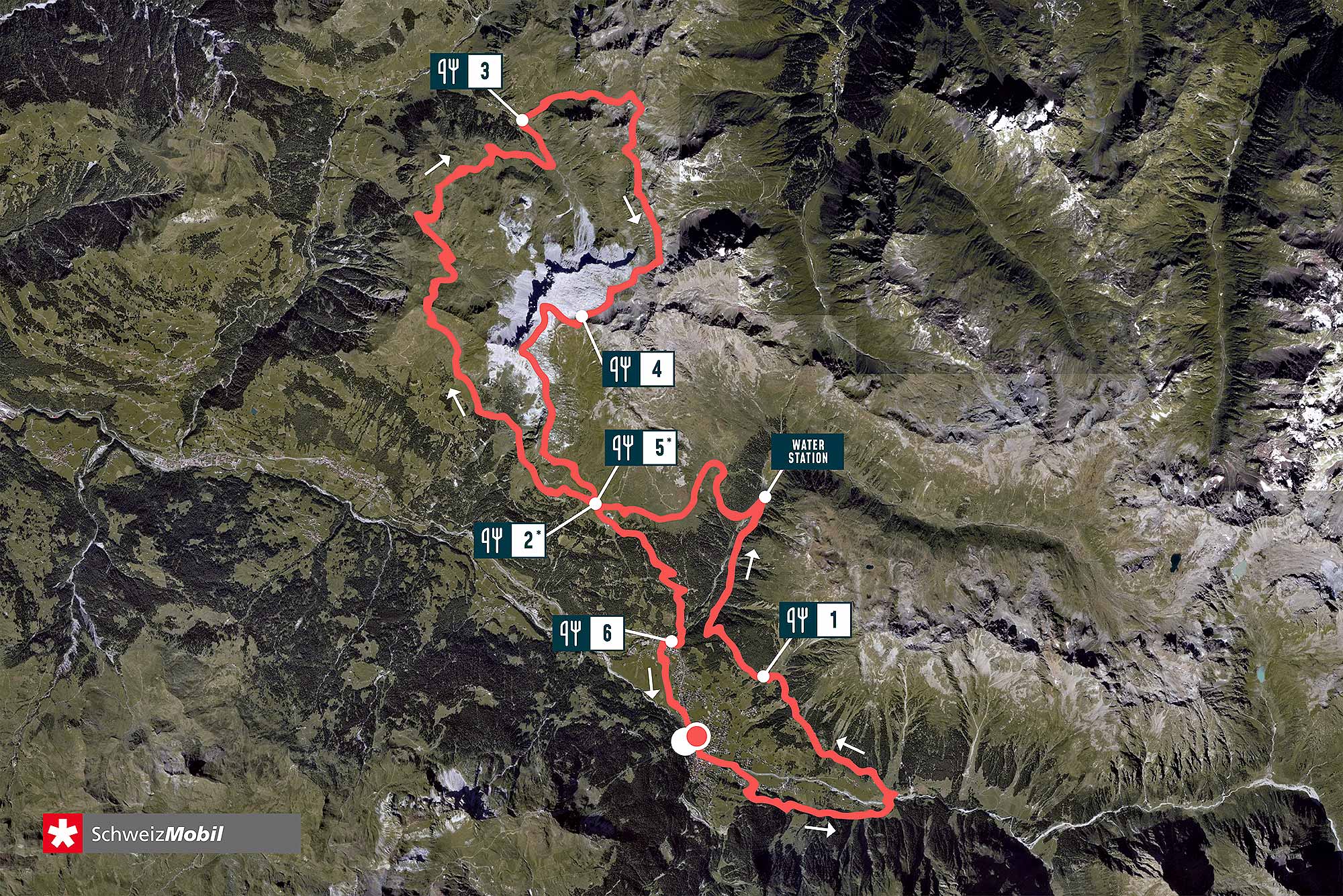
March table
| # | Waypoints | Altitude | Ascent (m) | Descent (m) | Distance (km) | To finish (km) | Time fast | Time slow | Time limit |
|---|---|---|---|---|---|---|---|---|---|
| 1 | Start Klosters Bahnhofplatz | 1.185 | 0 | 0 | 0,00 | 54,00 | 5:30 | 5:30 | – |
| 2 | 1 Alpenrösli | 1.447 | 690 | 430 | 9,30 | 44,70 | 6:15 | 6:50 | – |
| 3 | 2 Saaser Alp | 1.936 | 1.680 | 940 | 19,10 | 34,90 | 7:20 | 9:20 | 09:20 |
| 4 | Vordersäss Aschariner Alp | 1.800 | 2.350 | 1.580 | 28,70 | 25,30 | 8:00 | 10:50 | 10:50 |
| 5 | 3 Gafia | 1.670 | 2.695 | 2.080 | 33,40 | 20,60 | 8:50 | 12:10 | 12:15 |
| 6 | 4 Rätschenjoch (slightly below) | 2.550 | 3.935 | 2.460 | 41,70 | 12,30 | 10:30 | 16:00 | – |
| 7 | 5 Saaser Alp | 1.936 | 3.935 | 3.230 | 46,50 | 7,50 | 11:05 | 17:00 | 17:00 |
| 8 | 6 Klosters Dorf | 1.153 | 3.945 | 4.020 | 52,00 | 2,00 | 11:30 | 18:00 | – |
| 9 | Finish Klosters Bahnhofplatz | 1.185 | 4.020 | 4.020 | 54,00 | 0,00 | 11:45 | 18:30 | 18:30 |
The actual kilometers and altitudes vary depending on the measurement method between +/- 5%.
The carriage of mandatory equipment and the determination of cut-off times are mandatory for safety reasons.
Short-term, weather-related route changes are possible at any time.
Mandatory Equipment T54
Clothing
| ▢ | Trail shoes with a profiled sole |
| ▢ | Lightweight water- and windproof jacket |
| ▢ | Warm clothing (long-sleeved top or spare T-shirt and arm warmers + long trousers or leg warmers) as an insulating intermediate layer under the outer clothing. The basic rule here is that no skin should be visible! |
| ▢ | Changing shirt |
| ▢ | Gloves and hat/headband |
| ▢ | Headwear for protection from the sun |
Equipment
| ▢ | Headlamp |
| ▢ | Cup/container for drinks on the course |
| ▢ | Water container with 0.75 liters of drinks |
| ▢ | Food Approx. 500 kcal emergency provision |
| ▢ | Emergency equipment At least elastic bandage, whistle, rescue blanket |
| ▢ | Route map (GPX track on the watch or printed map) |
| ▢ | Mobile phone charged + saved emergency number |
| ▢ | Gel/bar packaging labeled with start number |
Die Liste beinhaltet die obligatorische Pflichtausrüstung. Die Renn- und Organisationsleitung behält sich vor, während des Briefings am Vorabend, diese Liste den Wetterverhältnissen entsprechend anzupassen.